Discover all possibilities
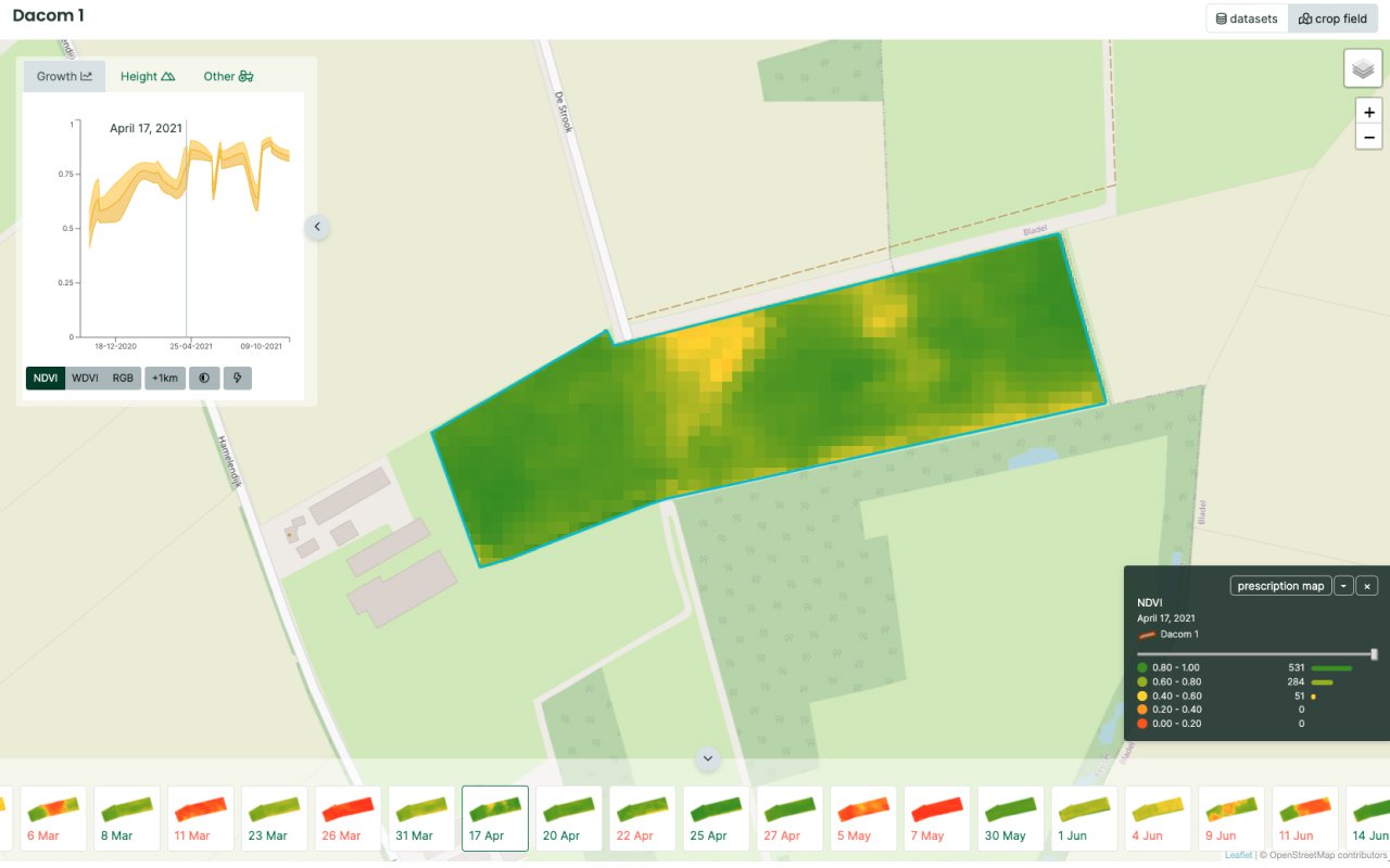
Direct insight into the variety of fields
With pre-prepared field data, histograms and statistics, Cloudfarm gives you direct insight into the variety occurring in your fields: soil type, altitude maps, NDVI, WDVI, soil potential, draining lines and shadow map.
Field data
In Cloudfarm you get for all fields:
- Soil type map
- Altitude maps
- RGB images
- NDVI images
- WDVI images
- Soil potential map
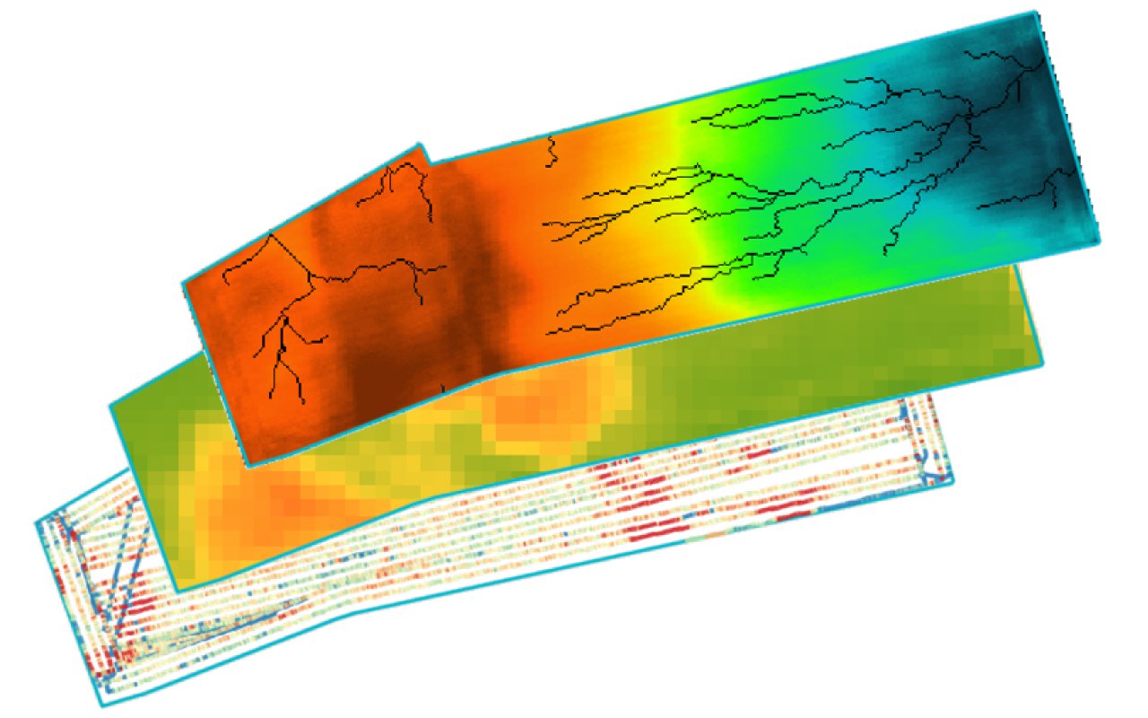
- Drainage lines
- Shadow map
More analysis with your own machine and sensor data
Import soil scans, drone images, yield measurements or machine tasks carried out. This way you can review precision spraying and even better analyse differences in soil, crop or crop treatment.
Importing machine and sensor data
Many businesses increasingly collect machine and sensor data. In Cloudfarm you can easily import this data manually. Examples are soil scans, yield measurements or machine tasks carried out. We call this “as-applied data”. This enables you to review precision spraying and other applications or to identify strong and weak parts in your field.
- Soil scans
- Drone images and link to www.dronewerkers.nl
- Yield measurements
- Machine tasks carried out
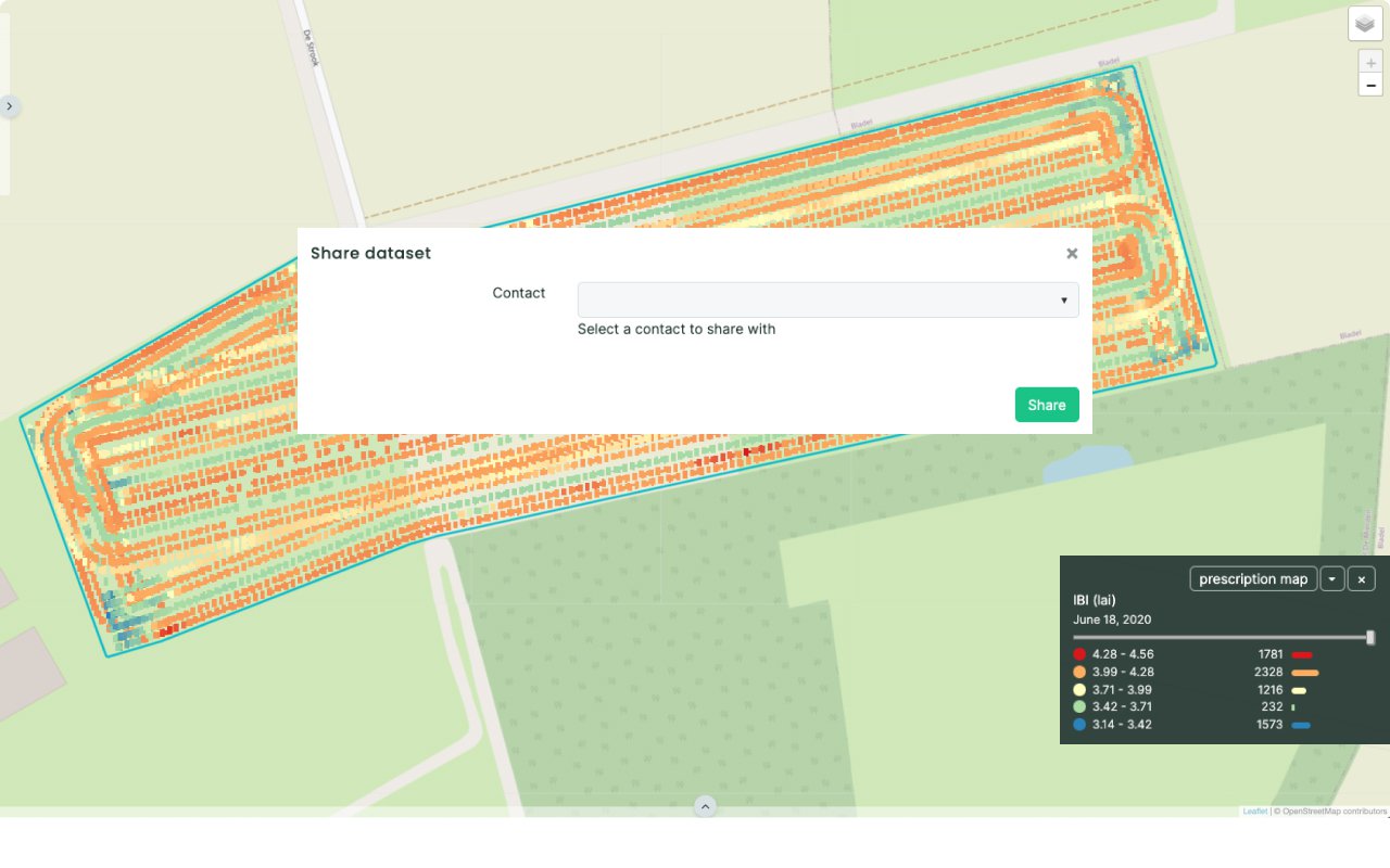
Share carried-out contract work with customers.
Print reports of carried out tasks. Or share carried-out contract work with customers digitally. For example the yield and humidity percentage of combine harvesting or the fuel use of ploughing or turning over the soil.
Reports and sharing
Print, analyse and share field data.
- Share
- PDF report
- Download CSV
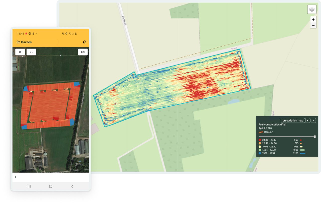
Scout fields with the Dacom Cloudfarm-app
With the Cloudfarm-app, you take all the field data with you in the field. With the GPS on your phone, you see exactly where you are. Once you are in the field, this is the perfect app to investigate the cause of differences in crop growth or yield.
Dacom Cloudfarm-app (iOS / Android)
- View field data
- GPS function
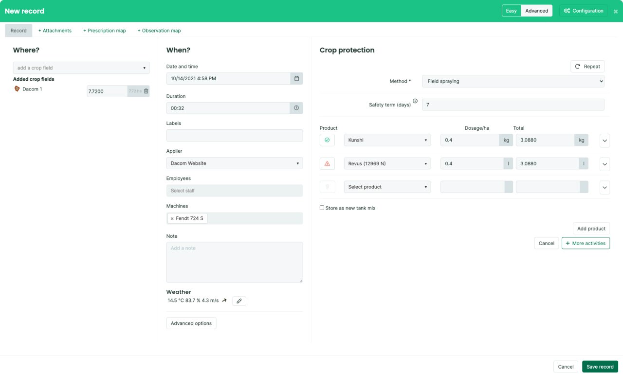
Creating prescription maps
Add a prescription map to a plan in your crop recordings with one click. You can see instantly what field data is available in Cloudfarm for the selected field. In addition to viewing standard application rate strategies, you can always manually change or colour classes and application rates on the map. By selecting machines and way lines, the working width and driving direction of the grid of the prescription map will be corrected automatically. When downloading, we create the correct map structure for the selected brand directly. It takes less than 5 minutes to create a prescription map.
When using the latest terminals, you can now operate multiple machines with different prescription maps. For example, for varied plant spacing and the simultaneous variable application of granulate or liquid nitrogen. You can make optimum use of your expensive agri inputs in this way.
- Prescription map generator
- Prescription map linked to Dacom Crop Recording
- Plan with multiple prescription maps
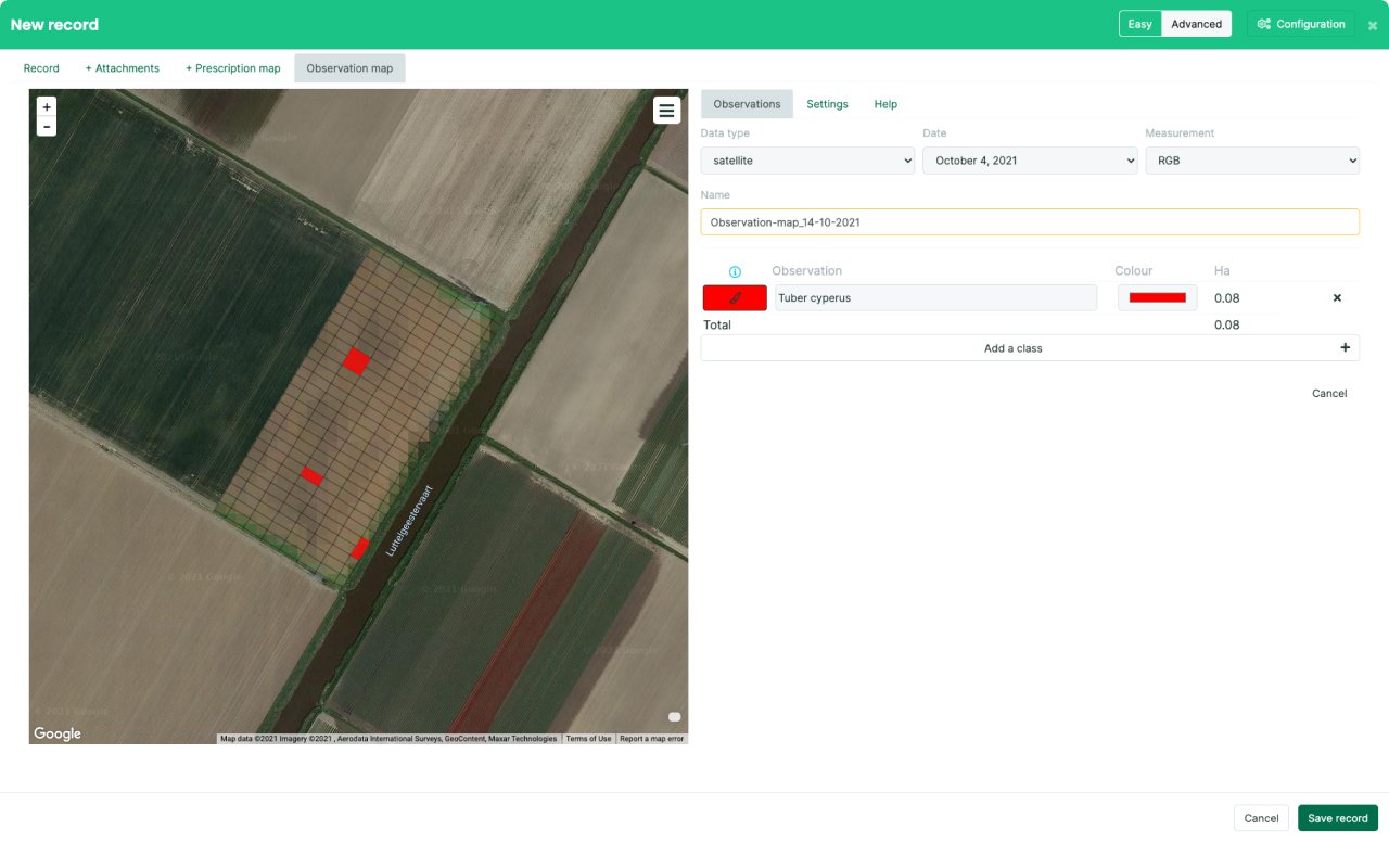
Targeted weed spraying with observation map
Many root weeds, such as thistles and yellow nutsedge, are concentrated in specific parts of the field. By recording these parts in an observation map, targeted spraying can be carried out later with a prescription map.
Observation map
Record your observations in Dacom.
- Observation map
- Observation in Dacom Crop Recording
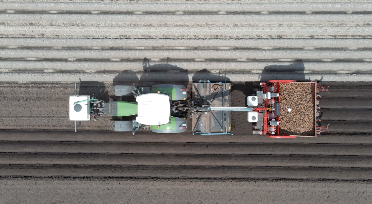
Mechan Group, partner of Cloudfarm
We are not developing Cloudfarm by ourselves. Since 2017 we have had a partnership with the Mechan Group. Together we take precision farming to the farmer. We do this by linking tractors to Dacom.
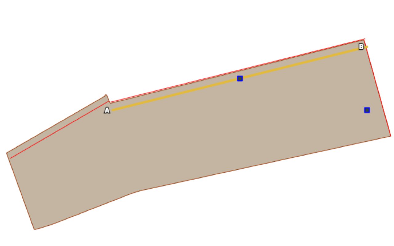
Working accurately by exchanging boundaries and way lines.
Working efficiently and accurately is one of the advantages of precision farming. With Cloudfarm, you can exchange field boundaries and way lines. This means all displays will work with the same data. You can also draw or move way lines yourself.
Exchanging boundaries and way lines.
With your GPS-controlled tractor and machine you can create way lines. They determine the driving direction on a field. With Cloudfarm, you can import and export field boundaries and way lines. That is useful for businesses with tractors and machines of different brands. Way lines can also be used to correct the grid of a prescription map.
You can also draw way lines or even copy them on the basis of the reference fields in Dacom. This level of accuracy is sufficient for a number of tasks. And that saves time. Way lines can also be moved. This means they can also be used by other machines than those that have created them.
- Draw way lines
- Move way lines
- Import and export: ISO-XML, Trimble, John Deere, SBG
- Set grid of prescription map with way line
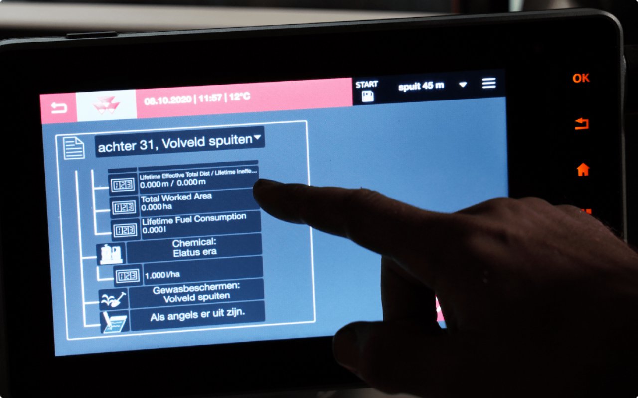
Link your tractors for convenience and speed
With our links, you can send a plan or prescription map wireless to your tractor. Tasks carried out in your terminal will automatically go to Cloudfarm. This means you only have to record crop data in one place.
Machine links
Link your Cloudfarm account to:
- AGCO Task Doc
- My John Deere
- AVR Connect
- Agrirouter
Automate your crop recording
Tasks carried out by machines are automatically linked to Dacom Crop Recording. We automatically copy as much data as possible, such as the treated area, the duration or the product application rate. This means less effort for you and more accurate reporting.
Automatic crop recording
Automatic recording in Dacom takes place:
- When using machine links
- When importing carried-out tasks manually
Cloudfarm Pro
-
-
Up to 300 hectares
Cloudfarm field data
- Soil type map
- Altitude maps
- RGB images
- NDVI images
- WDVI images
- Soil potential map
- Drainage lines
- Shadow map
Own machine and sensor data
- Soil scans
- Drone images and link to www.dronewerkers.nl
- Link to Bioscope
- Yield measurements
- Machine tasks carried out
Reports and sharing
- Share digitally
- PDF report
- Download CSV
Cloudfarm app (iOS / Android)
- View field data
- GPS function
Prescription maps
- Create prescription maps
- Prescription map linked to Dacom Crop Recording
- Plan with multiple prescription maps
- Export: Fendt, MF, Valtra, John Deere, Müller, Trimble, Shape, ISO-XML
Observation maps
- Create observation maps
- Prescription maps linked to Dacom Crop Recording
Field boundaries and way lines.
- Draw way lines
- Move way lines
- Import and export: ISO-XML, Trimble, John Deere, SBG
- Set grid of prescription map with way line
Machine links
- AGCO Task Doc
- My John Deere
- AVR Connect
- Agrirouter
Automatic crop recording
- When using machine links
- When importing carried-out tasks manually
Cloudfarm Premium
-
-
Up to 600 hectares
Cloudfarm field data
- Soil type map
- Altitude maps
- RGB images
- NDVI images
- WDVI images
- Soil potential map
- Drainage lines
- Shadow map
Own machine and sensor data
- Soil scans
- Drone images and link to www.dronewerkers.nl
- Link to Bioscope
- Yield measurements
- Machine tasks carried out
Reports and sharing
- Share digitally
- PDF report
- Download CSV
Cloudfarm app (iOS / Android)
- View field data
- GPS function
Prescription maps
- Create prescription maps
- Prescription map linked to Dacom Crop Recording
- Plan with multiple prescription maps
- Export: Fendt, MF, Valtra, John Deere, Müller, Trimble, Shape, ISO-XML
Observation maps
- Create observation maps
- Prescription maps linked to Dacom Crop Recording
Field boundaries and way lines.
- Draw way lines
- Move way lines
- Import and export: ISO-XML, Trimble, John Deere, SBG
- Set grid of prescription map with way line
Machine links
- AGCO Task Doc
- My John Deere
- AVR Connect
- Agrirouter
Automatic crop recording
- When using machine links
- When importing carried-out tasks manually
Cloudfarm Enterprise
-
On application
Contact-
More than 600 hectares
Cloudfarm field data
- Soil type map
- Altitude maps
- RGB images
- NDVI images
- WDVI images
- Soil potential map
- Drainage lines
- Shadow map
Own machine and sensor data
- Soil scans
- Drone images and link to www.dronewerkers.nl
- Link to Bioscope
- Yield measurements
- Machine tasks carried out
Reports and sharing
- Share digitally
- PDF report
- Download CSV
Cloudfarm app (iOS / Android)
- View field data
- GPS function
Prescription maps
- Creating prescription maps
- Prescription map linked to Dacom Crop Recording
- Plan with multiple prescription maps
- Export: Fendt, MF, Valtra, John Deere, Müller, Trimble, Shape, ISO-XML
Observation maps
- Create observation maps
- Prescription maps linked to Dacom Crop Recording
Field boundaries and way lines.
- Draw way lines
- Move way lines
- Import and export: ISO-XML, Trimble, John Deere, SBG
- Set grid of prescription map with way line
Machine links
- AGCO Task Doc
- My John Deere
- AVR Connect
- Agrirouter
Automatic crop recording
- When using machine links
- When importing carried-out tasks manually